
This cycle route passes through gentrified docklands and interwar housing, continues along the Amsterdam-Rhine canal and heritage villages, returning through Amsterdam’s newest suburb, IJburg. About 45 km, 5 hours, revised May/June 2023.
The route is printable, but not downloadable. Uploading a GPS file is easy, but there is no platform or format available, to upload a combined route and description. For general navigation (if you get lost) you can use Google Maps cycling option, and OpenStreetMap has a cycling layer.
start on the cycle path behind Centraal Station. The station was built in the 1880’s on an artificial island, cutting off the mediaeval waterfront.
facing the water, turn right, along the new cycle path. The quayside has been rebuilt: traffic now uses a new road tunnel, with the bus station on viaduct above.
the cycle path follows the waterfront, and then rises to a bridge. The concrete tower is for ventilation of the IJ-tunnel.
continue along the cycle path, passing the Amsterdam cruise terminal (with the curved roof), and new offices along the Oostelijke Handelskade or ‘eastern trade quay’.
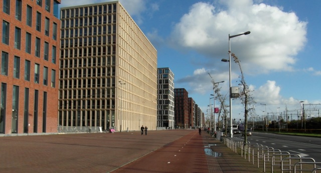
Behind the buildings is a former dock basin, part of of the eastern docklands. The basins and quays run east-west: they were built when the North Sea Canal made the port accessible to larger steamships. But since the canal ran west to the sea, it changed the direction of port expansion. As early as 1886, a purpose-built oil terminal, Petroleumhaven, was built west of the city. Despite the predictable shift westward, the eastern docks reached the height of their prosperity between the World Wars. They lost their function by 1980: warehouses were squatted by artists in the late 1980’s, as studio space. Arts, design and crafts are typical pioneers of gentrification.
pass a renovated 1930’s warehouse, De Zwijger (now a media/cultural centre). The lower floors were demolished, so that a road could run through the building.
pass more new offices and apartments: the road then curves, following the curve of the rail line.
The 19th century building, at the start of the the curve, is a former hydraulic power station. When electric motors were still weak, high-pressure water was an alternative means of distributing power: a similar system existed in the London docks.
pass the sub-surface tram stop (Rietlandpark, on the IJburg line). Stop at the objects which look like giant wooden tables. They are indeed giant wooden tables: this is Art. 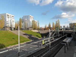 at the traffic lights (at the tables), turn right, alongside surface tram line 7, under the railway.
cycle on along the Czaar Peter straat: once a low-income area, now largely gentrified.
at the end of the street cross the bridge, and then turn left (sign for Almere). You pass the windmill De Gooyer. It was first built 1725, but rebuilt several times since. 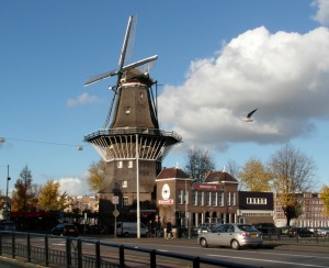 cross another bridge over the Singelgracht (former city moat), and carefully turn left at the traffic lights. You turn onto Zeeburger dijk: follow the cycle signs for Almere.
pass under the rail bridge, and turn right alongside tram line 14, into Borneo straat. Gentrification is spreading into this low-income area (Indische Buurt, built in the 1920’s).  go straight on, alongside the tram line, to Java plein, a square with small fountains.
at Java plein, cycle almost straight on, past FEBO fast-food. Go on into Java straat, toward the red 9-storey block on pillars.
cycle straight on past this block, over the cobblestones, and on across Java plantsoen (square), past the artistically carved boulders. This is the eastern edge of interwar Amsterdam.
slow down at the end of Java plantsoen: the steps here are not visible, until you are almost on them. Go down the steps, and through the low underpass tunnel.
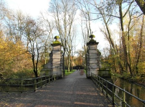
On the other side, on both sides of the cycle bridge, are the entrance gates of the former Jewish cemetery. A sign summarises the history: from 1714 to 1942, perhaps 150 000 people were buried here. Infant mortality was very high.
 cycle on into the park, Flevopark. At the pool, turn left, past the playground.
The pool served as a basin for an old pumping station, the white building. It is now a distillery and bar.
at the end of the path, turn right, at the tram lines (terminus lines 3 and 14). You pass the entrance of an open-air swimming pool (Flevopark bad, open summer only).
continue along the cycle path, parallel to the road viaduct. On the right is a dike breach lake – formed during the St. Elisabeth’s Flood of 1421.
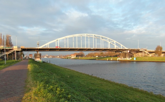
at the end of this cycle path, cycle up to the dike road of the Amsterdam-Rhine Canal and turn right, follow the sign for Almere.
Look back toward the arched road bridge. There are identical brick buildings on each side of the canal. This is the inlet siphon for the Amsterdam canal system, taking water from the IJ-meer (lake).
 continue along the dike road – it extends all the way to Utrecht along the canal bank. (The canal itself continues to join the main Rhine channel at Tiel).
pass on the right the buildings of the Amsterdam Science Park in Watergraafsmeer. Pass under the motorway bridge, and under the new cycle bridge, the Nesciobrug. (You will cross this cycle bridge on the return route). 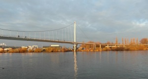 at the 19th-century redbrick house (nr 553), you enter the suburban municipality of Diemen (population 31 000). Continue along the canal bank.
pass right the 1990’s housing of Diemen-Noord. Across the canal, behind the trees, is the newest Amsterdam suburb, IJburg.
Diemen-Noord is a VINEX suburb, an abbreviation for the Fourth Policy Document on Spatial Planing Appendix (VIerde Nota ruimtelijke ordening EXtra). The policy, adopted in the 1990’s, concentrated suburban housing in large developments, at the edge of existing cities.
after the last apartment block of Diemen-Noord, there is is open farmland on the right, some converted to a rural park.
pass floodgates, separating the Amsterdam-Rhine Canal from a wide channel.
This is the Diem, a former tidal creek which gave its name to Diemen. The original fishing village was on your left, at the mouth of the creek.
pass under the new bridge to IJburg, and then under the triple-girder A1 motorway bridge.
pass under a second motorway bridge (opened 2016), and then cycle another 600 m along the canal bank, to a railway bridge.
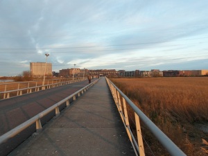
about 50 m before the arched rail bridge, turn right onto the cycle path, up to the railway embankment. The path makes a U-turn to the bridge.
cross the cycle bridge alongside the tracks. (You now follow Cycle Route 5, for about 1 km). Cycle down from the bridge, and continue along the cycle path, alongside the rail line.
The 4-track bridge was originally a smaller 2-track bridge. This is the 1874 Amsterdam-Amersfoort line, the route to the eastern Netherlands, and Berlin.
|
sources: settlement and landscape history |
about 1 km after the bridge, continue on this side of the rail line: follow the cycle sign for Hilversum. Don’t go under the railway line. (Route 5 turns off into Weesp here).
The new housing is built on what was open grazing land, until 2015. There are plans to fill the entire polder with housing, joining Weesp to Muiden. This case is typical of the planning issues, around all Dutch cities.
further on, pass the rear entrance to Weesp station. At the roundabout after the station, turn right, through the underpass under the rail line.
150 m further, turn left and cycle along the waterside road.
This is the river Vecht which flows on to Muiden – you will cross it there, on the return route. Originally the Vecht diverged at Utrecht from the Kromme Rijn, itself a branch of the main Rhine channel.
at the next corner, turn left across the lifting bridge, to continue along the river. (Route 5 also passes here). 
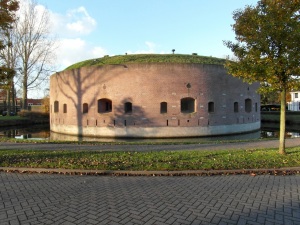
turn left over the next bridge, a wooden lifting bridge. After the bridge, pass the circular fort at Ossenmarkt: go around to to the right.
It was built in 1861, as part of a defence line around Amsterdam, the Stelling van Amsterdam. Weesp was a fortified town, part of the original inundation defences of Holland – the 17th-century Holland Water Line. Muiden was also fortified, and Naarden (5 km east) has the best-preserved fortifications in the Netherlands. The 17th century defences were expanded in the decades before the First World War, and again in the 1930’s. The Netherlands continued to build defensive lines until the 1960’s.
 continue across another bridge, and then turn left: follow the cycle sign for Muiden.
continue along the east (right) bank of the Vecht, and pass under the railway, again.
700 m after passing under the rail line, turn right into an access road, at a small redbrick transformer shed (Reaalspolder weg 1). The ‘dead-end’ sign does not apply to bikes.
cycle through open landscape toward the railway: this is the line to Almere.
As you near the railway, you can see the TV tower at Hilversum (the national broadcasting centre). The landscape with few farms is typical of reclaimed land. There was no dispersed peasant settlement (so no rural depopulation either). Note how absolutely flat the land is: the contrast will be clearer, when you reach Muiderberg.
cycle through the narrow tunnel under the rail line.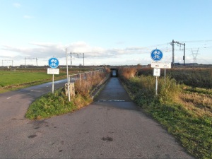
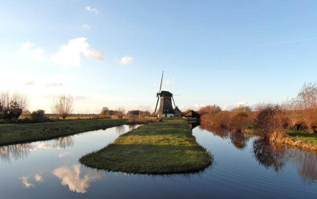
continue along a cycle path, and then a farm access road. To the left is a windmill, the trees ahead are in the Naardermeer nature reserve.
at the end of the farm access road, turn left, toward the windmill. Near the windmill, cross a small wooden bridge over the drainage channel (connecting to the Naardermeer lake).
The windmill was built for a second attempt to drain the lake, in 1809. The channel itself was built for the original drainage plan, in 1623. A few metres from the road is a blue enamel water level gauge, reading downward. The water level is about 1 m below sea level (NAP). Just after the bridge, on the corner, there are three concrete pyramids on the right, almost hidden by reeds in the summer. These are anti-tank defences, dating from before the Second World War.
go straight on from the wooden bridge, and go under the rail line (again). The road then loops around a pond, and climbs to cross the A1 motorway. On the right is a new rail bridge, for the Almere line.
after the motorway, at the traffic lights, go straight on, across the Muiden-Naarden road. Then cross a lifting bridge, over the towpath canal to Naarden, the Naarder Trekvaart.
The trekvaart system is known to economic historians as the most efficient pre-railway transport system. One horse on the towpath was enough to pull a barge, and the Netherlands were at an advantage in canal-building. The road beside the canal is the old high road from Amsterdam to Germany – the predecessor of the A1 motorway. (The old road ran via Naarden to Amersfoort, connecting to roads over the Veluwe ridge, to Deventer, Zutphen and Arnhem).
go straight on towards Muiderberg. Pass on the right two concrete bunkers.
They are part of a cluster of about 80 bunkers built around Muiderberg in the 1930’s. (Most of the Netherlands defences proved useless, against the German invasion of May 1940).
600 m after the bridge, at the Jewish cemetery, the road rises slightly. This is the north-western tip of the Gooi ridge.
This is the first land above sea level, east of the coastal dunes. In the early Middle Ages there was nothing but bog, creeks and mud flats, from here to Haarlem. (In fact, the marshlands of Holland were one of the last areas in western Europe to be settled). In other countries, ‘2 metres higher’ would be insignificant. But in marshland close to sea level, an extra 2 metres means different soil, accessible terrain, and no flood danger. The landscape type changes from grazing land with high water table, to wooded ridges with dry sandy soils. The Gooi ridge is a glacial ridge – pushed here by the Saalian Ice Front about 200 000 years ago.
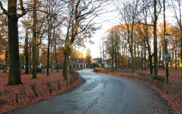 cycle on into the gentrified village of Muiderberg with about 3 300 inhabitants. Go straight on, through the village green (brink).
Muiderberg is unlike the linear polder villages north of Amsterdam. Genteel houses surround the ‘brink’ – originally common grazing land. Since 1703, the brink is a public park, probably one of the oldest in the country.
go straight into the village street, Dorps straat, with a few shops. Just after the shops, turn left into Bad laan – follow the sign for the Zuiderzeeroute cycle route.
This is the road to the beach. From 1882 to 1938, there was a steam tram from Amsterdam to Muiderberg, and on to Hilversum. Muiderberg was a small bathing resort from around 1800, and the tram made it a popular excursion from Amsterdam.
|
sources Muiden / Muiderberg / Zuiderzee Het Hart van Nederland: Steden en Dorpen rond de Zuiderzee Ph. Bosscher et al. 1973. Bussum: De Boer. Van Korre tot Koren ‘s-Gravenhage: Ministerie van Verkeer en Waterstaat. |
the street rises and opens out: stop in front of the small beach, looking over the IJmeer (IJ lake), and the reclaimed Flevo polder opposite. This ‘hill’, which gives the village its name, is at most 7 metres above sea level.
Until 1932 this was open tidal water. The land opposite, with the apartment blocks, did not exist. This was the Zuiderzee, a gulf of the North Sea – a dangerous sea. In the late Middle Ages, much of the village was washed away by storms. But at 13.02 on 28 May 1932, the last gap in the Afsluitdijk was closed, the most heroic act in the national mythology of reclamation. It converted the Zuiderzee into a fresh-water lake, the IJsselmeer. Reclamation of the polders began several years later. About 50 km of artificial land extends north-east from the beach opposite: the south Flevo polder (fully drained in 1968), the eastern Flevo polder (1957), and the Noordoostpolder (1942). In 1986 they were grouped into the Province of Flevoland.
In the polder, 5 m under sea level, is the new city of Almere – population zero until 1976, only 226 at the end of that year, and now 225 000. The Flevo polder is separated from the ‘old land’ by a randmeer, ring lake. The first lake polder, Noordoostpolder, was joined to the old land. When it was drained, groundwater level on the old land fell: the water drained into the new polder. To avoid that mistake, the later polders were built in the lake, leaving a wide strip of water (randmeer) to maintain ground-water levels. These lakes became recreational areas, worth more than the potential farmland. (In February 2010 this lake froze over completely).
you are halfway through the route. To go back toward Amsterdam, face the lake and turn left, from Bad laan onto Zee weg, parallel to the beach.
go on along the footpath, between the beach and a wood.
continue on the asphalt path, past the church (Kerk aan Zee), probably the highest point of Muiderberg. When the lake was still an open sea, this church was a landmark for sailors. 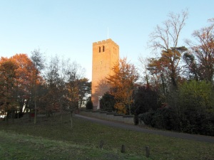 at the end of the path, pass the corner of Dijk weg, and go on another 40 m. Stop at the monument on the corner, a glacial boulder. It commemorates Floris V – Count of Holland and Zeeland, Lord of Friesland.
Floris granted Amsterdam a toll privilege, and that is regarded as the foundation date of the city. In 1296 he was captured by his enemies, while out hunting. A few days later, on 27 June 1296, they tried to take him as a prisoner through Muiderberg, but the population attempted a rescue. His enemies killed him on the spot.
go back to the corner of Dijk weg, and turn along this road, toward Muiden. Follow the sign for the Zuiderzeeroute cycle route.
The higher sand ridge ends here, and the old sea dike is on the right of the road. After 500 m the open, flat, reclaimed marshland is again visible: note the difference between the top of the dike and the water level in the ditches, the ‘maximum flood’.
cycle on alongside the dike, and pass the only building on the dike itself, Dijk weg 1. This is a typical dike house, one ‘safe’ storey at dike level, another below. Mind the chickens here.
after this house, the road bends left, into Noordpolder weg. Visible right is the castle of Floris V – or at least the later version, on the site of his castle.
at the end of this road, turn right, at the old pumping station for this polder.
It is now a private house, a plaque commemorates its opening in 1892. You are now back at the trekvaart (Amsterdam-Muiden-Naarden). On the opposite bank the first houses of Muiden (population 4 000).
cycle toward the grassed mound: it has chimneys. As you cross the wooden bridge, you can see it is also a 19th-century fort, Muizenfort.
It was designed specifically to fire along the length of the trekvaart. Behind it is another grassed mound with chimneys – a fortified barracks, built 1875-1880.
to go to the castle, turn right just after the wooden bridge, along the Ton Koot singel. After 70 m turn right, onto the footpath. Step off your bike, and walk along the 17th-century ramparts of Muiden.
The original military geography is intact: the line of the walls, the moat, and the open farmland on the other side. The ramparts were restored in 2021.
at the end of the path, go up to the bench on the rampart, for a better view of Muiden castle – Muiderslot.
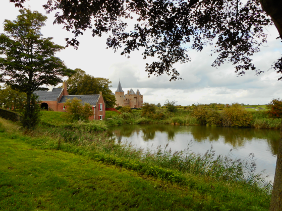
The castle is strategically located at the mouth of the Vecht river. Muiden is older than Amsterdam – even in Roman times, there was a north-south trade route, through Utrecht and along the Vecht. It connected the Roman cities along the Rhine with lake Flevo, the predecessor of the Zuiderzee. Later, the route south led to the Frankish trading city Dorestad. In the early Middle Ages the Vecht was controlled by the Bishopric of Utrecht, but from 1280 Muiden came under the control of the Counts of Holland, who maintained the castle there. As Amsterdam grew, the Vecht became more important as a defence line than a trade route: it protected the cities of Holland against an attack from the east. Centuries later, Muiden became part of the Old Holland Water Line, and the 19th-century Stelling van Amsterdam. The forts at the entrance to the village are from this last period: there is another 19th-century battery across the river from the castle. In the middle of the former estuary, the island Fort Pampus completes the circle around Amsterdam. The region was last fortified in 1939-1940.
continue to the castle entrance. If the gate is open, you can walk through for a closer look – the ticket office is further on.
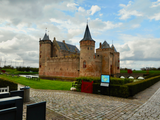
Muiderslot is the most famous castle in the country. It was built, or repaired, by Count Floris V around 1285, and expanded in the 14th century. In the Netherlands Golden Age, the ‘Muiden circle’ of artists and poets met here, as guests of the governor P. C Hooft. In 1825, the derelict castle was to be demolished, but it was the era of romantic nationalism, and the cultural elite protested. The building was saved – an early example of preservation inspired by nationalism. The castle became part of the schoolbook historiography of the Netherlands, along with Count Floris V.
to return to Amsterdam, first turn around. With your back to the castle gate, go straight on, and then along the river quay, Heren gracht.
This is ‘heritage Muiden’, note the flood wall on the waterside – until 1932 this was tidal water. The quayside cafes and restaurants are crowded in summer, with the yachting upper-class (and their imitators).
at the old sea locks on the Vecht turn right, across the old swing bridge (1870) toward Amsterdam.
The Vecht was originally tidal, almost as far as Utrecht. The first locks to control flooding were built around 1330 at Breukelen, and moved north in 1437. They were rebuilt here in 1673, at the mouth of the river. The locks were renovated in 2005.
stop after the bridge: there are two options, one along the road, one along the dike. In winter (November – February) the path along the sea dike is closed, to protect migrating birds. Use the winter route below. In summer, the dike path is open, but it is covered in sheep-shit, and only tolerable if the ground is totally dry. If it is raining, or has rained recently, then use the winter route.
Winter route: go straight on from the bridge, and cycle out of the village: the dead-end sign is not for cyclists. Continue along the canal for 2 km – there is construction work, but the route is open for cyclists. At the second power line, turn right across the bridge toward IJburg. Cycle on, with the Maxis shopping centre on your left. Go straight on, past the power station, and its cooling ponds. At the traffic lights, first cross the road, and then turn right along the cycle path. Follow the cycle sign for Adam-IJburg. Go on across two bridges toward IJburg, see below…
for the summer route (March-October), turn first right into Helling straat (the sign ‘Vonkplein’ is not the real street name). Pass old shipyards which are being converted to apartments: helling means slipway.
turn left into Stads steeg, and next right along Zee straat.
continue along Zee straat, between the dike and the back gardens.
pass the circular West Battery, an artillery position intended to control the mouth of the Vecht.
continue past new housing, some under construction. After the last house, a new cycle path begins, part of a new ‘nature boulevard’ along the old sea dike (opened 2011).
cycle on along the new path, mainly on the dike itself. In the lake you can see the island Fort Pampus. On the left is the former Muiden explosives works, now under development, with more construction sites.
The factory exploded in 1972, 1966, 1963, 1947, 1923, and 1883, see Buskruitfabriek “De Krijgsman”. It was originally a powder mill in Amsterdam: the city ordered it moved to Muiden in 1702. Why? Because it exploded. The plant closed in 2004 – an end to the industrial history of Muiden, which once had a salt works and shipyards.
the cycle path drops down from the dike, go straight on (with the dike now right of the path).
pass behind Diemen power station. Further on, pass under a concrete bridge, and immediately turn left, up the cycle path to the bridge. Make a U-turn, and cycle across this bridge.
The summer and winter routes rejoin here.
cross the bridge, and then a second bridge, into the new suburb of IJburg.
Built on expensive artificial islands, the suburb of IJburg is a prestige project of the city of Amsterdam – and one of the largest construction sites in the country. It will ultimately have 18 000 housing units, but falling average household size will cancel the entire housing gain.
after the longer bridge, at the bus stop, turn left across the bridge. Go toward the white triangular apartment block, with the rounded corner.
at the corner of the white block, turn right, into Ben van Meerendonk straat. The block should be on your right as you pass it.
go straight on. When you reach the shops, turn left onto the main avenue, Pampus laan.
at the tram stop, the wide avenue bends right. You are now on IJburg laan, the main axis of the development, with the tram line.


continue along this wide street. Just before the Albert Heijn supermarket, at the traffic lights, turn left into Vennepluim straat.
cross a bridge, and then turn right into Oeverzegge straat, follow the cycle sign for Diemen. Go on over the long cycle bridge.
go straight on, cross a raised road (the old sea dike), and cycle up to the cycle suspension bridge.
cross the bridge, and go back toward Amsterdam, along the bank of the Amsterdam-Rhine Canal, sign for A’dam-Centrum. (The return route is different from the outward route).
continue toward the arched bridge, which you saw on the outward route. This time, go under the bridge, to the small roundabout. Turn left here, along the footpath, not the road. (This raised path is also part of the old sea dike.)
pass on your left an apartment block, and go straight on along Zeeburger dijk, a long straight road (construction work, 2023).
pass under the rail line. At the traffic lights, turn right past windmill De Gooyer, and then right over the bridge.
instead of going back along the Czaar Peter straat, turn left along Oostenburger gracht, cycle sign for Centrum. At the end, turn left. Continue along Prins Hendrik kade to Centraal Station, the end point of this route.

Pingback: Amsterdam cycle routes – list | Amsterdam cycle routes